Less traveled trails in Krka National Park, part 1
- Laura Lilly
- Mar 17, 2020
- 7 min read
Updated: Dec 7, 2022
If you are a nature lover and want to avoid crowds, Krka National Park offers 22 trails of various lengths and difficulties (can be found here). Here I recommend the ones I have hiked alone or with families with children. Although most park trails are marked, I regularly come to intersections with multiple field paths and no signs. I use OsmAnd app on my phone, to navigate my way around the area and to find my car later if I end the hike in a slightly different location. With each trail description, I specify the length, terrain type, difficulty level, and crowd factor. Most of these trails are the same way in and out, so the distances I state are for one way only.
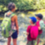
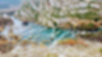
Foto courtesy of Susane Diane.
1. Skradin bridge to Skradin waterfall trail, Length: 3.4 km
Family and kid-friendly, easy hiking or cycling, could be busy
The best time of the year to hike this trail is off-season months (all except July and August). This is a fairly flat, gravel road that starts at the top of the canyon and eventually gets down to the river at the area of Skradinski Buk waterfall. For those who come to the park in July and August and wish to see its most famous waterfall, this way into the park is one of the less crowded alternatives. Car parking is available at the park parking lot in Skradin, and then a short walk along the Skradin lake, to the gated entrance into the park, where the trail begins. There is a parking area for about 10 cars along the road, right by the park entrance, but it is usually filled, so I never count on it. This is an easy hiking event for families with kids and cycling. Trail description here
2. Goriš village to Torak trail, Length: 2,9 km to the viewpoint
Family and kid-friendly leveled at first, then steep down to the lake, quiet
Parking is in the village of Goriš, on an empty lot that looks like someone's driveway. There is a park sign that points to the trail. The trail starts through an open area of the Miljevac plateau. The first stop is at an overview, looking down on Torak lake, the confluence of the rivers Krka and Čikola.

The trail continues down to the lake. At one point, the trail forked with neither direction being marked last time I was there. A narrower of the two paths, which lead through the old, metal gate, called to me, and I answered, entering the enchanted forest.

The area smelt moist and mossy, and gave me the feeling of calm and mysterious. The path opened up into a yard and a power station. I didn't see anyone out that day and enjoyed poking around undisturbed. The return was the same way. The trail description is here
3. Gluvo's trail, Length: 1,5 km
Strenuous descent to the Čikola river and back up the same way, quiet

Built by a local man whose nickname was Gluvo, meaning "deaf", this trail deserves respect and a meditative state of mind. It took Gluvo nine years to pave the way and built the track with his bare hands, moving every rock and carefully placing it, so that it stands there for eons to come. Parking is at the end of a gravel road in the village Brnjica, following the brown park sign. For the first 5 minutes, the trail stays on top of the canyon. A side trail joins on the left, with the big park sign telling about the Čikola river. The sign marks the trail. Shortly after, the trail comes to the edge, with a bench and a view down into the forest patch where Čikola flows happily and across to the Ključica fortress.
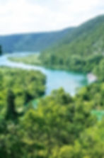
Čikola is only 48 km long, a seasonal river, with a magnificent canyon. Its name comes from the Turkish language and means "water through cliffs", which is a true representation of the rugged terrain through which it flows. The trail descends fairly steeply down to the canyon, with many switchbacks. Made from loose rocks means it does not give stable footing, so caution is needed. The constant sound of the river flowing hidden in those trees provided pleasant music to my ears. Ključica fortress perched on the cliff across the river gave me a sense of protection and safety. As I came closer to the river, the air became cooler and more musty smell. I didn't see a human all day. The trail description here

4. Ključica trail, Length: 1,8 km
Walking on loose gravel, good hiking shoes and hiking skills needed, quiet
This hike left me in a state of wonder about its main hero - the fortress Ključica. My 70+ years old mom and two nephews (ages 9 and 11) were with me.

The hike starts in the village Ključ, where we parked our car in front of an abandoned house and walked through olive groves and vineyards. Although the trail is marked, my OsmAnd app helped a great deal to keep us on the right trail and to show me an unmarked way right to the fortress. I was not going for anything less than getting between her walls. At one point, the trail splits in 3 directions. The most right path leads up to a viewpoint. The middle way leads down to the bottom of the čikola canyon and the bridge across the river. The most left way is the way that intrigued me because it looked like it was going right toward the fortress. Just as the view to the fortress opened up, the single track turned into a goat trail made out of the loose rock, on the side of a mountain. Luckily, we all had hiking boots on. My mom decided to sit on the rock and wait for us, while the boys and I went ahead slowly and carefully. I was mesmerized by the site of the ruins, pretending that I was in the Amazon forest, expecting to see a lost city, except my environment was dry and rocky. In about 20 minutes, we arrived at the fortress walls, standing at the very bottom of this monumental structure in the middle of the rock.


I couldn't think of why someone would decide to build it so high up on the rock. How did people access it back then? How long did it take them to carry so much stone? What was life like between its walls? We walked through the ruin to the other side, to only be humbled even more by its position, perched high above the river. From its location, a view opened to the river valley and the bridge across the river, used by many traders and locals to move across the region. The fortress provided protection from the Turks at some times, while at others it served as a control point for its owners, from where they rode their horses down and robbed merchands and local folks. I felt like if I looked down to the tinny snake of the river for long enough, I was going to transform into a bird and fly off freely. Instead, the winter sun was coming down and mom was waiting, getting cold. We headed back, but I knew then that I was going to be back for more quiet time to connect with the spirits of the past. The trail description here
5. Roški waterfall trail, Length: 1,5 km loop
Family and kid-friendly, except the steps to Oziđena cave, a few people can be seen
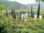
This is the trail on which I take our guests the most, and I never get enough of its scenery. To get to the trailhead and park entrance, we drive across the narrow, yellow bridge, and buy cheaper park tickets if park rangers are there. The trail starts to the left of the bridge and follows the river. This location is known for a series of small waterfalls, called Ogrlice, or Necklaces.

On the side of a cliff, there are 500+ wooden stairs, leading up to the Oziđena cave that provided shelter to men since Late Stone Age. Up there also, is a viewpoint, or the bird's view of Ogrlice and the canyon. Down the stairs and on, we cross a wooden bridge, visit with ducks happily treading upstream, and walk along the other side of the river, to the road and back across the yellow bridge. The gravel road continues to the right side of the bridge and takes us to a small village, with watermills turned into restaurants and a meadow that is the fairies' playground.
One of the mills turned into a restaurant has a terrace with tables that the river runs through, and with a pond for kids to get into and have fresh and cool water from atop hug their shoulders.

Our recommended lunch spot is Panorama Roški Slap, located before the yellow bridge. It's a family-owned restaurant, with good food, very affordable, the best service, and a terrace overlooking the river. One year on his birthday, Joe and I stopped here on an unplanned bike route and had lunch to load up on carbs before we ascended up the canyon and back to our car. Trail description here
6. Bilušića buk trail, Length: 300 meters
Family and kid-friendly, single track, descending at the beginning, quiet
Bilušića waterfall is the first, out of seven, on the Krka river, located at the furthest north part of the park.

The trail is just a short walk from the end of the gravel road where we park. It leads through lush vegetation, by fenced gardens of the locals, and a watermill, before it gets in front of the waterfall that has a huge mass of water rushing toward it. The tinny droplets spread all over the area, providing freshness in the summer heat. The surrounding rocks are dead travertines, showing the faces of imaginary river creatures. For a geology geek like I am, looking at the 125,000 years old rocks gives me an adrenaline rush. Trail description here


